
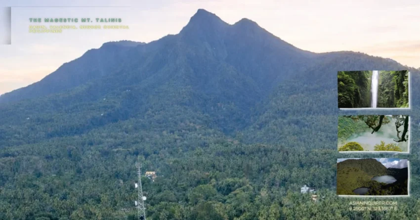
There is a place where the trees have ancient fingers that reach out from the soil to guide your every step.
Most people see the twin peaks from the coastal roads and wonder what lies behind the thick veil of clouds. You might think you know the Visayan landscape until you stand in the middle of a white wasteland smelling of sulfur.
The locals call this range Cuernos de Negros because the peaks look like the sharp horns of a giant beast rising from the earth.
This is not just a hike through a forest but a journey through multiple worlds in a single day. You will pass through emerald moss and then suddenly find yourself in a valley of dead trees and bubbling vents. The transition is so sharp that it feels like the mountain is playing tricks on your mind.
Reaching the summit requires a bit of grit and a lot of heart. It is the second tallest point on Negros Island and serves as the ultimate troubleshooting test for any mountaineer.
You will have to use your hands as much as your feet to conquer the technical ridges.
The roots are so thick and exposed that they form a natural ladder against the vertical slopes. It feels like climbing a massive beanstalk from a storybook while the mist swirls around your boots.
Every heavy breath is rewarded by a view of a silent crater lake that looks like a mirror for the gods.
You can hear the sound of the wind whistling through the prehistoric ferns. It is a sensory experience that defines the soul of Negros Oriental.
Mount Talinis is classified as a potentially active volcano because of its ongoing geothermal activity. You can see steam rising from the ground in the middle of the woods. It is a reminder that the mountain is breathing right beneath your gear.
I want to share the technical coordinates you need to master this epic trail.
You should prepare for an adventure that will stay in your memory for a lifetime.
The journey usually spans two days and one night of pure immersion. Most hikers choose to sleep beside the water where the temperature drops enough to make you shiver.
Lake Nailig serves as the primary basecamp for those chasing the sunrise.
It is a massive basin of water surrounded by jagged rock walls and ancient trees. You can sit on the shore and watch the reflections of the stars in the absolute silence of the high altitude.
The trail is diverse enough to keep your adrenaline high for hours.
You will never get bored of the changing scenery on this mountain.
One moment you are trekking through a grassy meadow and the next you are in a thick jungle. The ground is often damp and slippery which adds a layer of difficulty to the descent. You need to keep your focus sharp to avoid a sudden slip on the mossy stones.
This guide will troubleshoot every detail of your upcoming expedition.
Let us dive into the specifics of the jump off points and the fees required.
What is the difficulty of climbing Mount Talinis?
Mount Talinis is a major hike that carries a difficulty rating of 6/9 on the Pinoy Mountaineer scale. It stands at a staggering 1,903 meters above sea level which means the air gets thin and the climbs are very steep.
You should expect to spend between six to nine hours just to reach the summit depending on your pace and chosen trail.
This is the perfect choice for someone who wants to experience their first major climb in the Philippines. It is challenging enough to test your endurance but rewarding enough to make the pain disappear instantly. You will face technical sections where scrambling over large rocks and thick roots is the only way forward.
You should never underestimate the power of a volcanic ridge. Preparation is key to ensuring a successful and safe arrival at the peak. Do not underestimate the descent as the steep slopes can be quite taxing on your knees.
Many hikers find that the technical variety of the trail makes it one of the most interesting hikes in the Visayas.
Which trail should you choose for Mount Talinis?
You have three main options when mapping out your route which are the Bediao, Apolong, and Panghilakan trails.
The Bediao trail in Dauin is a favorite for those who want to see both Lake Yagumyum and Lake Nailig. It involves a steady uphill climb through a dense forest that eventually opens up to the first lake.
The Apolong trail in Valencia is the most diverse route because it passes by the famous sulfur vents and the twin falls. You will see the landscape change into a white wasteland where the volcanic gases have killed the surrounding vegetation. This trail is a masterclass in the geological history of the mountain range.
Choosing the right path depends on your level of fitness and your desire for adventure.
You can also choose to do a traverse which means entering through one trail and exiting through another. This is the best way to see all the major landmarks of the mountain in a single trip.
Most travelers prefer starting in Apolong and ending in Bediao to experience the cooling waters of the falls first.
Is a guide mandatory for Mount Talinis?
Bringing a local guide is a mandatory requirement for anyone wishing to explore these volcanic slopes. The mountain is a complex web of trails and it is very easy to lose your coordinates if the mist rolls in suddenly.
A guide not only ensures your safety but also shares stories about the local folklore and the history of the forest.
You can arrange for a guide through the tourism offices in either Dauin or Valencia depending on your jump off point. The current guide fee for the Dauin trail is around two thousand pesos per day for a group of up to five people. It is a small investment for the peace of mind of having an expert navigator by your side.
Porters are also available if you prefer to trek without the weight of a heavy pack on your shoulders. They are incredibly strong and can carry up to fifteen kilograms for a flat rate of two thousand pesos for the whole climb. This allows you to focus on the technical turns of the trail and the beauty of the surroundings.
Each step is easier when you trust the experts who call this mountain home.
How do you get to Mount Talinis from Dumaguete?
Dumaguete City is the primary gateway for this adventure because it is located only an hour away from the base of the mountain. You can reach the city via a direct flight from Manila or a ferry from the neighboring islands of Cebu and Siquijor.
Once you arrive at the port or airport you can easily find public transportation to the mountain towns.
Take a jeepney or a bus heading toward Valencia or Dauin from the city center. Once you reach the town proper you will need to hire a habal-habal to take you to the actual start of the trail.
The ride up to the jump off point is an adventure in itself as the road winds through lush gardens and small mountain communities.
Your expedition begins the moment you leave the urban streets behind. Ensure you stop at the official registration area to sign the logbook and attend the mandatory safety briefing. This is where you will finalize your guide arrangements and settle the small environmental fees.
The coordinates of the jump off points are clearly marked on most digital maps for your convenience.
What is the best time to hike Mount Talinis?
The dry season from January to May is generally the best window to climb if you want to avoid the muddy and slippery paths. This is when you have the highest probability of getting a clear view of the lakes and the distant sea from the summit.
However, be aware that some of the natural water sources on the trail might dry up during the height of summer.
Hiking during the rainy season offers a much more mystical and moody atmosphere as the mossy forest becomes incredibly vibrant and green. The mist is much thicker which makes the trek feel like an expedition through a prehistoric world.
Just be prepared with a high-quality raincoat and waterproof bags for your electronics.
A prepared hiker is a happy hiker in any weather. The temperature at the high campsites can drop significantly during the night regardless of the season. You should bring a reliable sleeping bag and layers of warm clothing to stay comfortable while you rest.
The mountain has a way of changing its weather coordinates in an instant so always be ready for anything.
Practical Travel Tips for DIY Travelers
If you are planning to organize your own climb you should contact the Dauin NegOR Tourism page at least a week in advance. This ensures that a guide is available and that you have the latest updates on trail conditions. Always bring more water than you think you need especially during the summer months when the mountain heat is intense.
Stock up on food and cooking supplies at the Dumaguete Public Market before you head to the jump off point.
You should try the local budbod which is a sweet sticky rice snack that provides excellent energy for the steep inclines. Make sure your trekking shoes have a very good grip because the mossy rocks near the lakes are notoriously slick.
Notable landmarks you should not miss include the slanting tree at the summit which is the iconic photo spot for every hiker. You should also take the time to visit the Casaroro Falls in Valencia if you have an extra day in the province.
The island of Negros is full of these hidden gems that are just waiting to be discovered by the adventurous soul.
We often climb mountains to see the world but we end up seeing parts of ourselves that we never knew existed.
Mount Talinis is a teacher that shows us the value of every heavy step and every deep breath. It reminds us that even when the path is vertical and the air is cold there is always a sanctuary waiting for us at the end of the road.
Frequently Asked Questions About Mount Talinis
1. How high is Mount Talinis?
The mountain stands at 1,903 meters above sea level and is the second highest peak in the Negros region.
2. Is it safe for solo travelers?
Yes, it is very safe provided you hire a mandatory local guide and follow the established safety protocols of the tourism office.
3. Are there wild animals on the trail?
You might see various species of birds and small lizards, but there are no large dangerous predators in the forest.
4. Can I drink the water from the lakes?
It is possible to drink the lake water, but it is highly recommended to boil it or use a purification tablet first.
5. How much should I budget for a DIY climb?
A budget of 3,000 to 4,000 pesos is usually sufficient to cover the guide fees, transportation, and food for an overnight trip.
6. Do I need special permits to camp?
The environmental fee paid at the jump off point serves as your permit to enter and camp in the designated areas.
7. Is there a mobile signal on the mountain?
The signal is very spotty and usually disappears once you enter the deep forest, though you might get a faint signal at the summit.
8. What should I do with my trash?
You must follow the leave no trace principle and carry all your waste back down to the town for proper disposal.
9. Can I hike it in a single day?
It is possible for very experienced and fast hikers, but a two-day trip is recommended to fully enjoy the scenery.
10. What is the nearest airport?
The Sibulan-Dumaguete Airport is the closest air hub and is located just minutes away from the city center.