
Have you ever wondered what it feels like to stand on a piece of land that is so close to the edge of the world you can almost hear the gears of the earth turning?
Batanes is the smallest province in our archipelago yet it holds a gravity that pulls at every traveler’s heart. It consists of three main islands named Batan, Itbayat, and Sabtang. Reaching this northern coordinate is a challenge that requires more than just a ticket because the climate here is a restless and unpredictable master.
Most people only see these rolling hills through the window of a tour van. I wanted to see if we could make the impossible possible by bringing our own motorcycle to the top of the map.
Returning from Itbayat to the Mainland
I woke up in Itbayat knowing we had reached the very top of the map.
We were surrounded by the ruins of ancient churches and the sharp scent of the sea. The red gasoline here costs 125 pesos per liter because the logistics of the north are a constant struggle.
I felt a surge of adrenaline as I shifted my motorcycle into gear for the steep descent toward the Valanga port.
The slope is so aggressive that you have to rely heavily on your engine braking to stay upright. If you look at the landscape you will see the road winding down like a ribbon into the crashing waves below. It is a transition that requires absolute focus and a steady hand on the throttle.
We loaded my motorbike onto the wooden boat for the three-hour crossing back to the mainland. The water was restless but our spirits were high as we prepared to explore the eastern side of Batan Island.
Reaching the Basco pier feels like coming home even if you have never been there before.
How to reach the Basco Lighthouse?
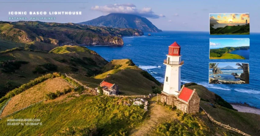
You can reach this iconic landmark in less than two minutes if you are coming from the town proper. It stands sixty feet high on Naidi Hills where the grass is always a vibrant shade of green.
This lighthouse was built on the site of an old American-era bunker that once served as a vital communication hub.
I noticed traces of the 1941 bombings etched into the landscape during my walk toward the viewing deck. You have to climb fifty-three concrete steps to see the panoramic view of the town and the ocean.
The silence at the top is heavy and comforting during the sunset hours.
Just remember that drone flights are strictly forbidden between seven in the morning and three in the afternoon. The proximity of the airport makes this coordinate a high-security zone for all aircraft.
This is a rule you must troubleshoot before you unpack your gear. You should wait for the late afternoon when the sun hits the stones of the lighthouse in a way that looks like a painting. It is the perfect time for a selfie or a moment of reflection.
The Naidi lighthouse is a beacon of resilience that has seen the history of Batanes unfold through many generations.
Where is the best view of the Pacific Ocean in Batanes?
The Tayid Lighthouse in Mahatao offers a perspective of the Pacific that few other places can match.
It was built in the year 2000 and features a unique hexagonal shape with six distinct corners. The name comes from an Ivatan word that means to pull because the ancient boats were often hauled up here during the fierce northern storms.
Standing fifty-six feet tall it acts as a sentinel over the eastern coast of the island.
You can see the second highest peak called Mount Mataram from the balcony. To the north the clouds usually gather around the peak of Mount Iraya which is a volcano that watches over the town. The air here is so fresh that it feels like you are breathing in the sky itself.
This is the oldest lighthouse in the province and serves as a vital guide for travelers crossing to Sabtang. It is a coordinate where the green mountains meet the infinite blue of the sea.
The wind here is a constant reminder of the raw power of the northern climate.
Finding Peace at Marlboro Hills (Racuh A Payaman)
Most people call this place Marlboro Hills but the locals know it by its traditional name which means a wide and rich pastureland.
Raku means big and wide while payaman refers to the land where the cattle graze freely under the sun.
You should arrive here before seven in the morning to see the sun rising over the green hills. The sunlight is soft and the grass is often covered in a thin layer of dew that sparkles like diamonds.
I saw only a few cows and goats wandering across the slopes as I walked toward the edge of the cliff.
The view from these hills justifies why Batanes is often called a paradise on earth. It is a landscape that will leave you speechless and make you forget about the noise of the city.
You must pay a small environmental fee of fifty pesos at the registration desk before you enter. Make sure you bring your visitor number because the wardens check every traveler for safety and documentation. It is a simple technical process that helps preserve the beauty of these coordinates for the next generation.
The Racuh A Payaman is where the soul of Batanes truly resides.
Is there a swimming pool in South Batan?
Rakuh-a-idi is a hidden coordinate that features a man-made pool just a few meters away from the salt spray of the ocean. It was once a fortress and a settlement for the early Ivatan tribes who needed a secure place to live.
The pool is fed by fresh mountain water that is so cold it will make you catch your breath.
Locals used to believe that these waters possessed the power to cure the sick and restore the spirit. I sat in a small wooden hut nearby to watch the waves hitting the rocks of the Pacific.
You are strictly prohibited from smoking or drinking alcohol in this sacred area.
Management also requires you to carry all of your trash back to the town proper. This leave no trace policy is the reason why the water remains as clear as glass.
If you are tired of the pool you can easily walk down to the rocky beach and listen to the tide.
The fountain of youth at Rakuh-a-idi is a sanctuary you cannot afford to miss.
We continued our road trip through the mountains of Uyugan where the goats cross the road without warning. You must stay alert and keep your speed below forty kilometers per hour to avoid any accidents on the narrow curves. The winding roads here are a dream for any motorcycle rider who loves the feeling of the open air.
We reached a high viewpoint that looked like a skyway built directly on top of the ridges.
Why is the Alapad Rock Formation iconic?
The road here was literally cut through the center of a mountain range to allow travelers to reach the south.
You will see a massive sign that says blow your horn as you approach the sharp curves. This is the most famous signage in Batanes because the spot is both beautiful and potentially deadly if you are not careful.
Honking your horn warns the oncoming vehicles that you are navigating the narrow passage.
The Alapad rocks look like giant fingers reaching out to the sea. You can see the different layers of stone that have been weathered by centuries of typhoons and heavy rain. It is a geological masterpiece that serves as a backdrop for the most iconic travel photos in the region.
I noticed how the rock formation actually divides the different weather patterns of the island. On one side the wind is calm while on the other the Pacific waves are crashing with incredible force.
This is a coordinate where the earth and the sea are in a constant battle for dominance.
Practical Travel Tips for Batanes DIY Travelers
- Registration: Always carry your visitor pass and registration number. Most viewing decks and lighthouses will ask for this before you enter the property.
- Drone Rules: Respect the seven to three no-fly rule in Basco town. Troubleshooting your flight schedule is essential if you want to get that perfect aerial shot without legal trouble.
- Fuel: Gasoline is significantly more expensive in the north. Gas up at the Petron station in Basco before you head to the southern towns or Itbayat.
- Clothing: Even in the summer the mountain wind can be sharp and cold. Bring a light windproof jacket or a hoodie for your long motorcycle rides.
- Cash: Most places in Batanes do not accept digital payments or credit cards. Withdraw enough cash in Manila or Clark because ATMs in Basco are notoriously unreliable.
- Respect: Batanes is a province built on trust and deep honesty. Always ask for permission before taking photos of the local Ivatan people or their beautiful stone homes.
- Safety: The coastal roads have many blind curves and steep drops. Keep your speed low and always follow the blow your horn signs to stay safe.
- Food: Try the local Ivatan platter for about 280 pesos. It usually includes uved meatballs and pork preserved in its own fat.
- Timing: Sunrise is the best time for Marlboro Hills while sunset is perfect for the Basco Lighthouse. Plan your coordinates around the movement of the sun.
- Connectivity: Signal is decent in Basco but disappears in the mountains. Download your maps for offline use before you leave your homestay.
Batanes teaches us that being small does not mean you are insignificant. A province that can be circled in a single day holds enough stories and beauty to last a lifetime.
We often travel to find something new but in the silence of the rolling hills we end up finding the version of ourselves that we lost in the noise. The road ends at the cliff but the journey of the spirit continues long after you park your bike.
Frequently Asked Questions (FAQs)
1. How long is the boat ride from Batan Island to Itbayat?
The crossing usually takes between 2.5 to 3 hours depending on the sea conditions and the type of vessel.
2. Can I fly a drone anywhere in Batanes?
No, there are strict no-fly zones near the airport and town proper between 7 AM and 3 PM. You also need a DNR permit.
3. What is the entrance fee for Marlboro Hills?
The environmental fee is approximately 50 pesos per head as of 2026.
4. Is there an ATM in Itbayat?
No, there are no ATMs in Itbayat. You must bring all the cash you need from the mainland or Basco.
5. What is the best month to visit Batanes for a motorcycle trip?
The dry season from March to June is the best time to avoid typhoons and enjoy calm sea crossings.
6. Can a standard automatic scooter handle the roads in Batanes?
Yes, but a semi-automatic or a high-clearance bike like the Himalayan is much better for the steep and rough patches.
7. How many steps are there in the Basco Lighthouse?
There are 53 steps leading to the viewing deck at the top.
8. What does “Idi” mean in the Ivatan language?
Idi means community or settlement.
9. Is it safe for solo female travelers to ride in Batanes?
Yes, Batanes is widely considered one of the safest provinces in the Philippines with a very low crime rate.
10. Do I need a tour guide to visit the lighthouses?
While you can go on your own, having a guide is helpful for navigating the small roads and learning the history of each coordinate.