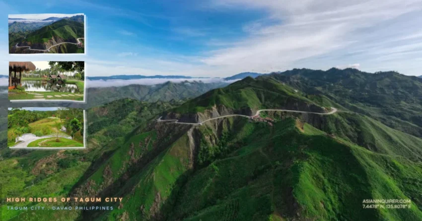
You might find yourself staring at the horizon in Tagum City and wondering which of the many mountain paths will lead to the most breathtaking view.
The city greets you with wide three-lane roads that feel more like a modern runway than a standard provincial street. It is a refreshing start for anyone who has endured the suffocating gridlock of the capital.
This is the best city road you can take before the pavement begins to tilt toward the sky.
I shifted my motorcycle into sixth gear and kept the RPM low to save on fuel while the wind hit my riding gear. The center islands are lined with small palm trees that look like they are standing at attention to watch you pass. You realize how lucky the people of Mindanao are to have such a vast freeway for their morning commute.
The traffic was heavy because it was rush hour, yet the road was so wide that we never had to slow down. I dream of coming back to these specific coordinates just to run that long stretch of asphalt again.
It is a smooth transition from the urban bustle into the rural heart of Davao del Norte.
What makes Tagum City roads so special for riders?
The flyover in Tagum makes you feel like you are riding on a skyway high above the busy local intersections.
You look down and see the city moving beneath you while you glide toward the mountains without a single stoplight to break your rhythm. It is a cinematic experience that stays in your memory long after you have parked your bike for the night.
The morning sun reflected off the polished chrome of my handlebars as we headed toward the municipality of Asuncion.
We maintained a steady pace of sixty kilometers per hour to troubleshooting our fuel consumption in the rising heat. My digital display showed an impressive economy of over twenty-seven kilometers per liter because we weren’t constantly braking.
It is a rider’s paradise where the road is free and the scenery changes from city malls to lush coconut groves in minutes.
Where is the best mountain view in Talaingod?
The real magic of the trip begins at the coordinates of Route 192 in the town of Talaingod.
We navigated the uphill curves that riders love so much until we reached the Balimba Hills Activity Center in Barangay Santo Niño. For a modest entrance fee of twenty-five pesos, you are treated to a lush landscape where the mountains seem to ripple like green waves toward the horizon.
The glasswalk there provides a unique thrill for those who are not afraid to look straight down into the deep forest canopy.
This is the perfect spot to take a breather and let the cool mountain air reset your internal compass.
You can see the clouds hanging low over the peaks as if they are waiting for the sun to set. It is a relaxing view that makes all the sweat of the lowland ride disappear instantly.
Is the road from Talaingod to San Fernando safe?
The road between Talaingod and San Fernando is a masterclass in the rugged geography of Mindanao.
You will encounter snake roads with banking curves that demand your full focus and absolute respect for the terrain. I noticed several piles of loose rocks along the shoulders, indicating that this is a high-risk area for landslides during heavy rain.
It is a freeway experience that makes you realize how powerful nature is in this part of the country.
We crossed into San Fernando, Bukidnon, and were greeted by a massive welcome arc featuring statues of majestic eagles.
There was no guard at the viewing deck near the border, so we climbed the path to see the overlooking vista. The air turned noticeably colder as we gained altitude and left the dusty trails behind us.
The road was wide and empty, allowing us to lean into the turns with confidence.
We passed by several mountain resorts where the ridge views were so spectacular they could compete with any famous tourist destination.
It is a long journey through the clouds that reminds you why you chose two wheels over four.
Where can you find a hidden cafe in Valencia City?
Finding a quiet sanctuary near Valencia City requires a bit of grit and a high-clearance motorcycle.
We followed an off-road path that Google Maps barely recognized, leading us through a steep gauntlet of big rocks and loose gravel. Our engine stalled once on a particularly sharp incline, but the struggle was a necessary part of the adventure.
We finally reached the Apo Ridge View Cafe just as the golden hour began to paint the sky in shades of amber.
The entrance is only twenty pesos, and you can bring your motorcycle right to the edge of the cliff for a selfie.
I sat under a shady tree and enjoyed a cold milkshake while the wind whistled through the mountain grass. You are not allowed to bring outside food, but the unique “lovers’ cottages” are available for only fifty pesos if you want a private spot to eat.
It is a secret coordinate that rewards the brave with silence and a 360-degree view of the valley below.
The descent back to the city was just as thrilling as the climb.
Can you experience a sea of clouds in Bukidnon?
The final stretch of our journey took us to the heights of Barangay Banlag where the earth meets the sky.
We passed a quirky pink gas station inspired by Hello Kitty, where even the staff wore matching uniforms to brighten up the roadside. It was a fun and unexpected stop that added a bit of humor to our rugged mountain expedition.
We pushed toward the Countryside Paragliding site, hoping to catch the famous sea of clouds.
The road was cemented but very steep, requiring us to downshift frequently to manage the vertical climb.
While the clouds were not thick enough to create the “sea” effect during our stay, the clearing was absolutely magnificent. You can see the entire city of Valencia and the vast rice fields stretching out like a patchwork quilt below your boots.
The wind here is strong enough to support tandem paragliding for those looking for a high-altitude adrenaline fix.
It costs around three thousand five hundred pesos to fly over the valley with a professional pilot.
The temperature at the top was freezing, making our heavy riding jackets a mandatory piece of gear for the afternoon.
We stood on the glass walk and watched the sun disappear behind the jagged mountain silhouette.
Practical Travel Tips for DIY Travelers
- Fuel Strategy: Gas up in Tagum City or Valencia proper. While there are small stalls selling bottled gas, a full tank is safer for the long mountain stretches.
- Navigation: Download offline maps for the Talaingod-Valencia route. Signal is spotty once you enter the deep mountain passes.
- Gear: Wear layers. The lowlands are sweltering, but the ridges in San Fernando and Banlag are cold enough to make you shiver.
- Bike Choice: A high-clearance motorcycle like an adventure bike or a dual-sport is ideal for the off-road paths leading to Apo Ridge.
- Safety: Watch out for horses and livestock on the road in the countryside. The locals still use horses as a primary mode of transport.
- Landmarks: Don’t miss the Hello Kitty gas station for a unique photo op and a quick fuel top-up.
- Budget: Carry plenty of small bills. Entrance fees for viewing decks and cafes are usually between 20 to 50 pesos.
- Timing: For the best chance at a sea of clouds, arrive at Barangay Banlag before 6:00 AM.
- Respect: Always greet the locals with a smile. A simple “Maayong aga” (Good morning) or “Maayong hapon” (Good afternoon) goes a long way.
- Nearby Spot: If you have time, visit the Pulangi River in Valencia for a quick look at the local water system.
We often spend our lives searching for a clear and easy path without realizing that the most beautiful places are hidden behind the most difficult turns. The road to the mountains teaches us that silence is a destination we have to work for every single day of our lives.
I hope your next journey leads you to a coordinate that makes you stop and realize how small your daily worries actually are in the grand design of nature.
Frequently Asked Questions
1. How long is the drive from Tagum to Valencia City?
The total travel time can range from 4 to 6 hours depending on your pace and how many scenic stops you make along Route 192.
2. Are the roads in Talaingod fully paved?
Most of the main highway is paved, but there are sections under construction and areas prone to landslides with loose gravel.
3. Is it safe to ride a motorcycle through these mountains at night?
It is not recommended due to the lack of streetlights, unpredictable weather, and the risk of stray animals or road debris.
4. How much does it cost for a day tour at Balimba Hills?
The entrance fee is very affordable at only 25 pesos per person.
5. Can I bring my own food to Apo Ridge View Cafe?
The management generally prohibits outside food to support their own restaurant, but drinks are available for purchase.
6. Do I need a special permit to go paragliding in Valencia?
No, you can simply walk in and register with the local operators at the jump-off point in Barangay Banlag.
7. What is the best month to visit Bukidnon for a road trip?
The dry season from January to May offers the clearest skies, though it can still be quite cold in the highlands.
8. Are there ATMs available along the mountain route?
No, you should withdraw enough cash in Tagum City or Valencia before heading into the remote barangays.
9. Is the Hello Kitty gas station a real fuel station?
Yes, it is a fully functioning gas station that has become a popular roadside attraction for travelers.
10. What is the entrance fee for the San Fernando viewing deck?
Many of the public viewing decks along the border are free to access, though some privately managed spots may charge a small fee.