
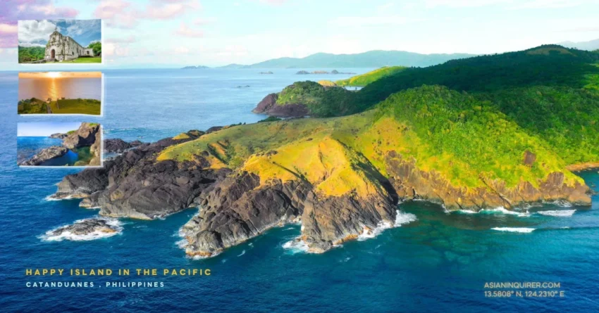
You might wonder why a place sitting directly in the path of the Pacific’s strongest typhoons is known as the Happy Island.
Catanduanes is a province that defines resilience through a smile. People here face the roar of the ocean every month, yet they recover with a speed that defies logic.
My journey to these specific coordinates began with a long sea crossing from Albay.
I arrived at the port of Virac, the capital town located at the southern tip of the island. It is a place that feels surprisingly organized for a region that is still developing its tourism infrastructure. You will see high buildings and busy malls that remind you of a smaller, cleaner version of a metropolitan hub.
The city center revolves around the Virac Town Center and the public market. Here, the local commerce is thriving alongside international banks and boutique hotels.
The Urban Pulse of Virac Catanduanes
The streets of Virac are wide and offer a refreshing sense of order the moment you step off the ferry.
You can walk from the sea wall to the public market in just a few minutes. It is a hub where traditional island life meets modern convenience.
I noticed that the hospitality here feels genuine rather than manufactured for tourists.
Chasing the Coast to the Municipality of Baras
Leaving the capital behind, the road opens up into a long stretch of coastal scenery that looks like a desert during low tide. The water recedes so far that the golden brown sand becomes a vast playground for the eyes.
This journey to the municipality of Baras takes about forty five minutes. I was glad to have a private vehicle because the island is much larger than it appears on a small map. You really need to be in control of your own timing to see the best spots.
The air smells of salt and fresh mountain air as you enter the jurisdiction of Barangay Guinsaanan.
The Emerald Majesty of Binurong Point
Binurong Point is the coordinate that everyone talks about when they mention the beauty of the province.
The jump off point is tucked away in a quiet village where local student guides greet you with warm smiles. These students balance their education with their roles as guardians of the cliffs.
To reach the summit, you must navigate a twenty five minute trek through stone stairs and mossy forest paths.
Lessons in Local Lore and High Altitude Peace
I appreciated how clean the trail was despite the popularity of the location. The guides are very strict about the leave no trace policy because the land is privately owned.
You won’t find dangerous wild animals here, but you should definitely watch out for the organic landmines left by the cows.
The moment the horizon opens up, you will realize why this place is compared to the rugged coastlines of Ireland.
Velvet green grass covers the rolling hills while massive limestone cliffs drop straight into the churning blue of the Pacific. It is a world class view that feels like standing in a high definition computer wallpaper. You can see the three different points of the ridge stretching out like fingers into the ocean.
Troubleshooting Your Island Travel Logistics
There is a deep historical reason why this ridge is named Binurong by the local people.
In the local dialect, the word comes from buro, which refers to the ancient practice of preserving fish with salt. Before electricity arrived, ancestors would bring their catch up here to ferment it in the cool mountain air.
Another interpretation of the name translates to “heal” in the English language.
These hills were once home to countless medicinal herbs used by traditional healers for generations. You can still feel a sense of spiritual tranquility as the wind brushes through the tall grass.
Looking out toward the water, you will spot the iconic formation known as Sayaw Rock.
Legend says that during World War II, the Japanese mistook this rock for an American battleship and bombed it repeatedly. The impact made the massive stone shake in a way that looked like it was dancing in the waves. That is how it earned its unique name which remains a favorite story for every tour guide.
Planning a DIY trip to the happy island requires some careful logistical troubleshooting. The best way to get here is via a RORO ferry from the port of Tabaco in Albay.
Make sure to bring a reliable power source if you plan to explore the remote northern towns where the grid can be unpredictable.
I brought an EcoFlow Delta 3 to keep my Starlink and camera batteries charged during the long drives. It is light enough to carry and can handle the heavy power needs of my morning coffee.
The True Meaning of the Happy Island
The island of Catanduanes is much more than just a collection of beautiful sights.
It is a place where safety and joy are the primary coordinates of every community. I spent my second day observing the local life and noticed a profound sense of peace that is rare in busier provinces.
The people are jolly and welcoming despite the many storms that cross their shores every year. This resilient spirit is the true reason why it is called the Happy Island. You will leave with a full heart and a new perspective on what it means to be happy.
Travel isn’t just about reaching a destination on a map.
It is about the stories you find in the silence of a cliffside.
We often rush through our lives looking for the next big thrill. Sometimes we just need to sit on a hill with a cow and watch the sun set over the Pacific.
Practical Travel Tips for DIY Travelers
- How to Get There: Take a flight to Virac Airport or a RORO ferry from Tabaco Port, Albay to Virac Port. The ferry ride takes about 3 to 4 hours.
- Binurong Point Fees: Prepare 40 PHP for the entrance fee and 30 PHP for the environmental fee (Total 70 PHP per head).
- Best Time to Visit: Aim for the dry season from March to June for the best hiking weather and clear views.
- Dress Code: Wear comfortable trekking shoes. The trail can be slippery after a light rain.
- Landmarks: Visit the Virac Town Center (VTC) for supplies and check out the historic Bato Church nearby.
- Safety: Catanduanes is widely considered one of the safest provinces in the Philippines. The locals are very helpful to solo travelers.
- Transportation: Renting a car or motorcycle in Virac is the most efficient way to reach Baras and other northern towns.
- Connectivity: Signal is strong in Virac but can be spotty at the cliffs. Download offline maps for navigation.
Frequently Asked Questions (FAQ)
1. Is Catanduanes safe for solo female travelers?
Yes, it is known for being extremely safe and peaceful. The local culture is very respectful and welcoming.
2. How long is the hike to Binurong Point?
It is a relatively easy trek that takes about 20 to 30 minutes depending on your pace.
3. Why is it called the “Happy Island”?
The name comes from the resilient and cheerful nature of the locals, who maintain a positive outlook despite being frequently visited by typhoons.
4. What is the “Sayaw Rock”?
It is a rock formation that reportedly “danced” or shook when it was bombed by the Japanese who mistook it for a battleship.
5. Are there ATMs in Catanduanes?
Virac has several major banks and ATMs, but they are scarce in the smaller municipalities like Baras.
6. Can I fly a drone at Binurong Point?
Yes, but you must follow local regulations. Avoid flying near the Virac airport during restricted hours.
7. How much is the ferry fare for a vehicle?
Freight for a standard vehicle from Albay to Virac typically starts at around 3,000 PHP.
8. What language do they speak in Catanduanes?
The local language is Bicolano, but almost everyone is fluent in Tagalog and English.
9. Is there a mall in Virac?
Yes, the Virac Town Center (VTC) serves as the primary shopping and lifestyle hub of the city.
10. What is “Buro”?
It is a traditional Filipino method of fermenting or pickling fish or vegetables with salt.